Spencer Carter![]() is engaged with ongoing research into the Mesolithic period of north-east Yorkshire and the North York Moors.
is engaged with ongoing research into the Mesolithic period of north-east Yorkshire and the North York Moors.

Current activities
- Post-excavation and surface scatter spatial analyses of Mesolithic lithic assemblages from the Westerdale and Glaisdale areas of the North York Moors, including 23 new radiocarbon dates from late 6th to early 4th millennium cal BC
- Characterisation of Late Mesolithic to Early Neolithic activity and the palaeo-environment in the lowland zone within the vale of Guisborough, Redcar & Cleveland, with ongoing field reconnaissance
- Mapping Early Mesolithic activity in the south Tees catchment (Deepcar-resonant) and late glacial to Holocene continuums in the river catchments of the Vale of Mowbray (Rivers Tees, Swale, Ure and their tributaries)
- Managing the future disposition of, and sustainable curation for, private prehistoric archaeological collections related to north-east Yorkshire and the North York Moors
By example
Unpicking the Palimpsest
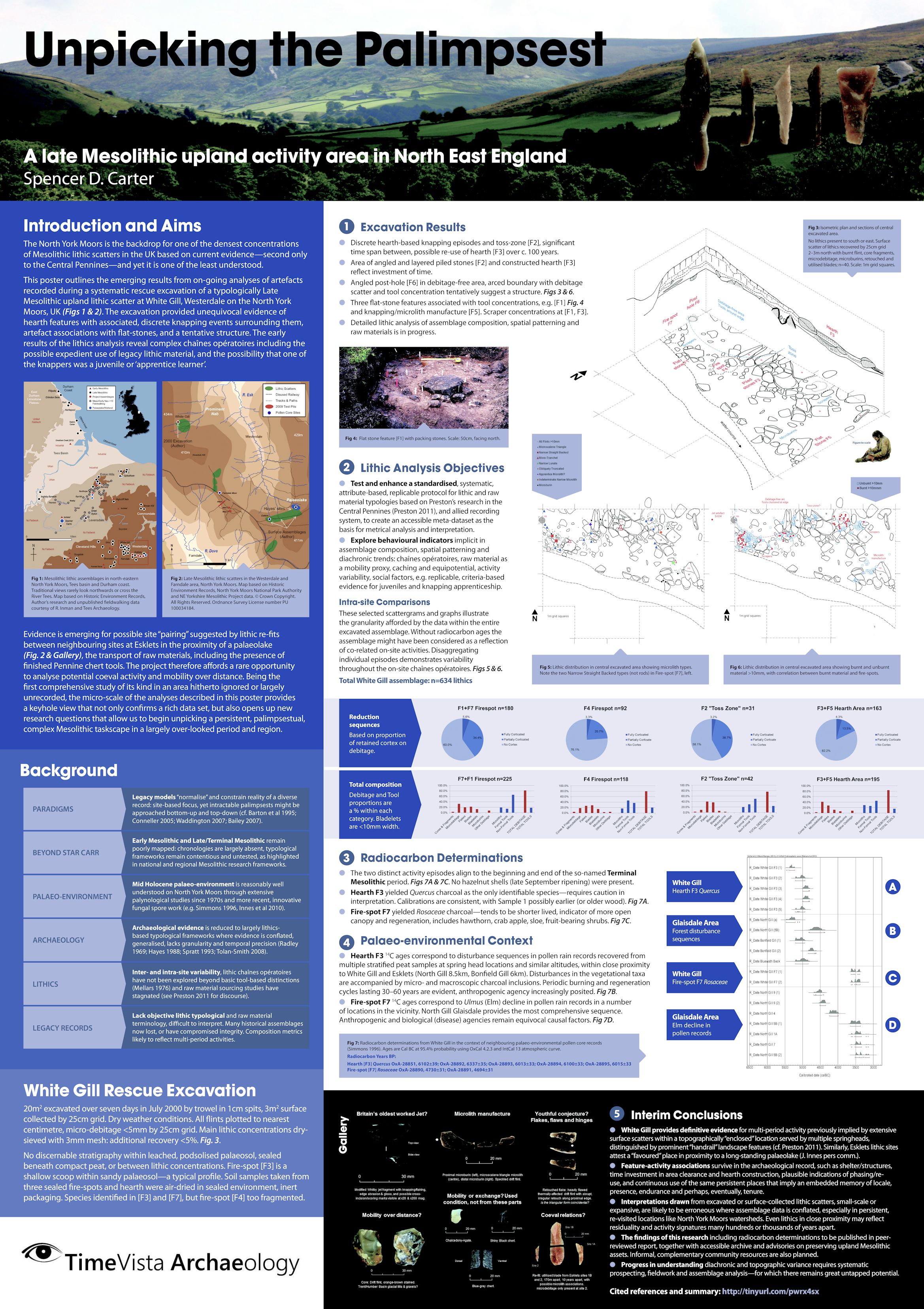 The North York Moors is the backdrop for one of the densest concentrations of Mesolithic lithic scatters in the UK based on current evidence – second only to the Central Pennines – and yet it is one of the least understood.
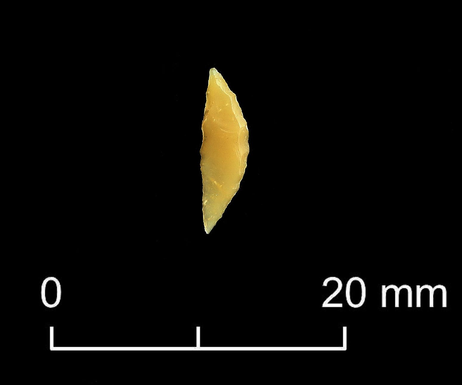
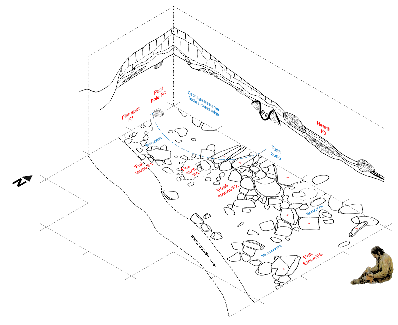
The emerging results from on-going analyses of artefacts recorded during a systematic rescue excavation of a typologically Late Mesolithic upland lithic scatter at White Gill [Note 1] are compelling, with dated horizons in the late 6th millennium BC and early 4th millennium BC. The excavation provides unequivocal evidence of hearth features and burning episodes associated with discrete lithic knapping and deposition events, artefact associations with flat-stones, and a tentative structure. The early results reveal complex chaînes opératoires including the possible expedient re-use of legacy lithic material.
Chronological resolution
 There are now ten AMS radiocarbon determinations from White Gill, the latter three generously grant-funded by the National Park Authority, and thirteen overall for the immediate area. These provide the first and only cohesive calibrated sequence for north-east Yorkshire outside the research focus on Star Carr and the Lake Flixton area in the Vale of Pickering. The latest White Gill dates, based on short-lived Corylus avellana (hazel), seems to relate to transitional Terminal Mesolithic to Early Neolithic activity (or at least a terminus post quem burning event) in what appears to be extended Late Mesolithic persistence into the fourth millennium cal BC, around the 39th to 38th century BC – a short period where there is also evidence for an Early Neolithic mortuary structure and domestic activity (the latter securely dated in 2016) in the coastal zone at Street House, Loftus. The latest suite of radiocarbon dates at Street House, from salterns and pottery kilns, are due in late 2025. The salt-making is the earliest recorded in Britain and some of the earliest in western Europe (Dr Stephen Sherlock, pers comm).
populating a taskscape
 In addition, evidence is emerging for possible coeval site “pairing” suggested by lithic re-fits between neighbouring assemblages (better termed surface ‘collections’), along with three new radiocarbon dates and a full palaeo-environmental sequence, at Esklets, a few kilometres to the south in the proximity of a small palaeolake that was a body of open water throughout the Mesolithic [Note 2]. The transport of lithic raw materials over considerable distances including the presence of finished Pennine chert tools, white flint from the south-east, and possible stained flint sourced from the Trent basin. Isolated lithic finds and possible caching events are also included, extending to the Glaisdale area where palaeo-environmental sequences – with posited periodic anthropogenic burning events – are also well defined.
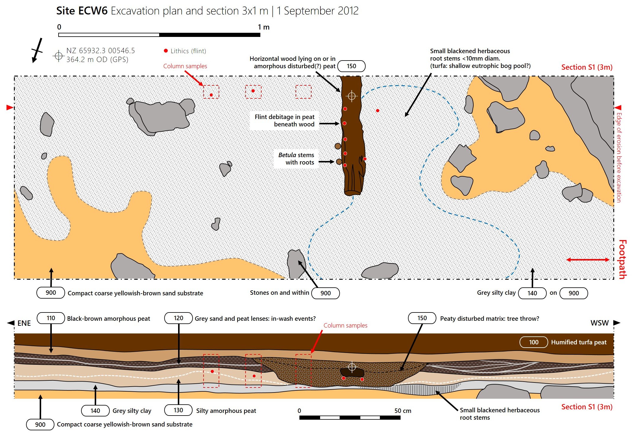 Rescue excavation of an eroding footpath has revealed in situ Late Mesolithic flint debris and tools, together with a full environmental sequence from the Mesolithic into the Neolithic and Bronze Age². Anthropogenic signatures are evident in pollen cores, demonstrating different degrees of direct and indirect impact on the landscape.

The project therefore affords a rare opportunity to analyse activity and mobility through time and over distance. Being the first comprehensive study of its kind in an area hitherto ignored or largely unrecorded, the micro-scale ‘bottom-up’ analyses provide a keyhole view that not only confirms a rich data set – albeit it one at risk from erosion and land management practices – but also opens up new research questions that allow us to begin to unpick a persistent, palimpsestual, complex Mesolithic taskscape in a largely over-looked period and region.
Ongoing Research
Late Mesolithic Hunter-Gatherer Transitions at Esklets, Westerdale, North York Moors 5000-3700 BC is presently a research project but with future potential for community engagement based on analysis and dating of peat and sediment samples. This phase is supported here by Dr Jim Innes (Durham University Geography) for environmental and pollen analysis and Dr Seren Griffiths (Manchester Metropolitan University) for Bayesian modeling of radiocarbon dates [Note 3].
 The aim of this grant-funded project is to reconstruct the cultural and environmental history at Esklets, on Westerdale Moor on the watershed plateau of the North York Moors in North Yorkshire, which is undergoing severe erosion of the blanket peat that covers the moors, exposing several ‘narrow-blade’ Late or Terminal Mesolithic activity areas (“sites”). These sites are under threat, and are being destroyed by erosion, by land management, by heavy use of adjacent footpaths and by unrecorded flint collecting by the public. The project is trying to research the sites through excavation and scientific analyses before they are destroyed. Several are already badly affected. Read more »
Further Reading
- Read more and download the White Gill poster [academia.edu] »
Additional background information will be uploaded here shortly, including an A4-size poster summary, lithics catalogue, artefact scattergrams and bibliography - Site monitoring and archaeological summaries for Esklets 2016 [PDF] »
- Site monitoring and archaeological summaries for White Gill 2016 [academia.edu] Forthcoming
- Waughman, M. 2017. Hunter-Gatherers in an Upland Landscape: The Mesolithic Period in North East Yorkshire. Yorkshire Archaeological Journal 89: 1–22
DOI https://doi.org/10.1080/00844276.2017.1333333 - North-East Yorkshire Mesolithic Project 2006–15 [website] »
 Highly Recommended
- Conneller, C. 2022. The Mesolithic in Britain Landscape and Society in Times of Change. Routledge.
Notes
¹ Carter, S.D. 2014. Unpicking the Palimpsest: a late Mesolithic upland activity area in North East England. Poster presentation at Where the Wild Things Are: Recent Advances in Palaeolithic and Mesolithic Research Conference, 8-10 Jan 2014, University of Durham [Online paper: academia.edu, includes handout with bibliography].
Please note that the most recent (three) radiocarbon determinations from White Gill are not yet included, pending Bayesian modeling and further analysis of the lithic material culture [Note 3].
² Albert, B. and Innes, J. 2015. Multi-profile fine-resolution palynological and micro-charcoal analyses at Esklets, North York Moors, UK, with special reference to the Mesolithic-Neolithic transition. Veget Hist Archaeobot 24: 357–375 | DOI https://doi.org/10.1007/s00334-014-0488-5
³ Carter, S.D. 2025 In prep. Radiocarbon determinations from rescue excavations at three Late Mesolithic sites, Westerdale, North York Moors, England. Document will be linked here.
Acknowledgements
In addition to personal funds, I am extremely grateful to the following organisations for grants towards pollen analysis and radiocarbon dating:
- North York Moors National Park Authority (NYMNPA)
- Yorkshire Archaeological & Historical Society (YAHS)
- Quaternary Research Association (QRA)
- Association for Environmental Archaeology (AEA)
